
VIP member
Survey Plan for Power Grid Drone Disaster Damage
Power grid UAV disaster damage exploration plan 1. Typical natural disasters in the industry pain points, such as extremely heavy rainstorm, landslide
Product details
Exploration plan for power grid drone disaster damage
1、 Industry pain points
Typical natural disasters, such as extremely heavy rainstorm, landslides, etc., usually cause certain damage to power lines, and post disaster line survey usually brings many inconveniences due to road damage. The pain points of the business include:The efficiency of manual inspection is low, dangerous areas are difficult to reach, and fault location takes a long time.
Drones can be used to arrive at the scene as soon as an emergency occurs, locate problems from an aerial perspective, and provide data support for subsequent repair tasks.The advantages of drones include: safety and efficiency, intelligent tools for surveying the site, ensuring operational safety, and scientifically developing repair plans and schedules through various methods such as 2D maps, high-definition photos, and videos.
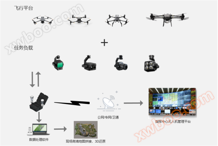
2、 Scheme architecture

3、 Main functions
Line digital map, emergency plan
By updating the 3D model of key distribution lines through drones or airport timing, the generated model can be imported into the contingency plan platform for emergency plan formulation and rescue plan deduction.
Digital contingency plans, relying on GIS geographic information platforms, load and integrate 3D models to facilitate accurate mapping of key facilities, fire water sources, and other combat elements around key routes. At the same time, emergency routes can be deployed in real-life situations, which can further improve the efficiency of emergency combat.

Emergency event reporting and verification
Emergency incidents occur, receiving reported incidents, the emergency command center dispatches drones and airports, verifies event information and on-site conditions, and based on the rapid panoramic composition and modeling capabilities of drones, forms an event report map to assist in the development of emergency plans.
The emergency command center can use the drone video scheduling capability and collaborative combat capability provided by the emergency command platform to push videos to mobile terminals such as mobile apps through video streaming, meeting the needs of the command center and front-line personnel to share and view videos around the event and understand the situation.

By using a tethered system and unmanned aerial vehicles equipped with loudspeakers, it is possible to provide lighting for the scene, monitor the situation and development trend in real time, and remotely command collaborative operations on site in combination with unmanned aerial vehicle loudspeakers.
When the accident occurred, the power communication network was paralyzed. Through unmanned aerial vehicles and image transmission, real-time feedback of the scene was possible to monitor the situation on site.

Based on the captured images and point cloud data during the inspection of disaster stricken lines, disaster damage identification is carried out through image recognition algorithms and point data analysis, mainly including the identification of fallen poles, tree obstacles, broken wires, and broken strands.
Image recognition can be achieved through edge computing power (such as the built-in computing power of portable airports), or central computing power, where drones collect images and transmit them back to the center for recognition.
Tree obstacles and disconnections can be collected by drones to obtain the latest point cloud data of the line, which is then transmitted back to the center for analysis by the center's point cloud data processing software.

Online inquiry
-
Contacts
-
Company
-
Telephone
-
Email
-
WeChat
-
Verification Code
-
Message Content
-