
VIP member
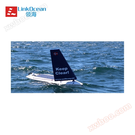
Sailbuoy Ocean Wind Unmanned Cruise Observation System
Norwegian Offshore Sensing AS was established in 2014 as a commercial subsidiary of Christian Michelsen Research.
Product details
Introduction to Offshore Sensing AS:
Norwegian Offshore Sensing AS was established in 2014 as a commercial subsidiary of Christian Michelsen Research. CMR has been producing anchor systems and drifting buoy products for a long time. Drifting buoys are inexpensive, easy to deploy, and can be communicated via satellite. However, drifting buoys have many limitations as they quickly drift past areas of interest to users, thus limiting their practicality and operational time. Therefore, in 2005, based on the basic principle of drifting buoys, CMR envisioned designing an instrument mounted platform that would not drift over areas of interest to users, and could conduct fixed-point observations without the need for anchor systems, giving rise to Sailfloat. In 2009, a series of on-site tests were conducted on Sailbuoy, including offshore and open sea testing, to further improve the design and enhance quality. So far, Sailuoy has become a mature commercial product, and Offshore Sensing AS company is currently developing, producing, and selling Sailuoy.
SailboyIntroduction:
Sailbuoy is the world's first ocean autonomous cruise observation system with long-term endurance capability. It will not easily drift over the sea area of your interest, and can be observed at a fixed point without the need for anchoring.
Sailbuoy Ocean Wind Cruise Observation System is an unmanned automatic observation system that can be equipped with various marine environment monitoring instruments (waves, water quality, meteorology). It relies on wind navigation to maintain in-situ fixed-point observation and can also automatically cruise or cross oceans in large areas. Through the Iridium communication system, users can engage in real-time remote communication and navigation tracking control with Sailby.
The standard Sailbody is 2m long, with a displacement of 60kg and a load of 10kg. It is equipped with 30W solar panels and can cruise continuously at sea for up to 12 months. The cruising speed is 1-2 knots (maximum 3 knots) and the offshore wind speed is 3-30 m/s.
")
")
Sailbuoy Wind Powered Unmanned Ship
")
Storm? Low visibility? roaring waves? A piercing cold wind? Dangerous waters? 10 level wind? Wave height of 10 meters?
sendSailbuoygo to sea!
Sailby application
1. Observation of marine hydrological and meteorological data
2. Wave measurement
3. Water quality monitoring
4. Collect underwater data and offshore data transfer stations
5. Monitoring and early warning of oil spills at sea
6. Tracking of Red Tides at Sea
7. Monitoring of marine animals and schools of fish
8. Ocean information collection
9. Collection and transmission of underwater seismic signals
10. Sea Signal Transfer Station
Sailby's main features:
1. Powered by wind, designed with low power consumption and extremely low energy consumption
Sailuoy uses wind as its propulsion force, and its navigation is very similar to traditional sailboats. Sailuoy can automatically calculate the navigation route based on the position of the waypoint, and the automatic navigation does not require human intervention. It can turn forward against the wind and approach the user-defined waypoint position, making it very suitable for long-term independent combat. In addition, Sailbuoy contains specially designed low-power electronic units with very low power consumption, which can sail continuously for months in extremely low or even no solar energy environment conditions, without relying on solar energy for navigation, making it very suitable for use in high latitude and low light areas.
")
2. Adapt to harsh marine environments
Sailbuoy is very sturdy and durable, and its design and testing are carried out in extremely harsh marine environments, such as strong winds and waves, piercing cold winds, extremely low lighting, and low visibility. A large number of tests have shown that Sailbuoy performs very well in harsh environments and can withstand various obstacles and sea ice at sea, even exhibiting excellent performance in level 9 sea conditions.
3. Strong endurance capability
Sailbuoy is specifically designed for long-term missions and can work continuously at sea for several months to one year.
4. Easy to place and recycle
Sailbuoy is compact in size and lightweight, weighing only 60kg. It can be easily lifted by two people and is very easy to place and recycle. Almost any vessel can be used to deploy and retrieve Sailbuoy, such as speedboats, lifeboats, fishing boats, and ocean engineering ships, without the need for professional personnel for deployment and retrieval.
5. No threat to offshore facilities
Sailbuoy's unique design ensures that it will not be damaged or entangled with floating debris, anchoring systems, and other offshore structures. And it can withstand collisions with sea ice or floating debris without experiencing rupture, entanglement with debris, or being swept into the bottom of the water. There will be no potential threat to offshore structures.
6. Strong carrying capacity
Sailbuoy can be equipped with a Datawell Moses G1000 wave sensor, which is a sensor based on a single GPS wave measurement principle for continuous and long-term observation of wave height, direction, and period. Sailbuoy can maintain in-situ fixed-point wave observation without the need for anchoring, and can continuously measure waves in a large area of a sea area. Sailby can automatically navigate to the destination sea area and return after completing the task, avoiding the cost of wave buoy deployment and retrieval. The wave parameters are calculated in real-time and sent back to shore via satellite. At the same time, the raw data is saved in the ship's data collector and can be downloaded and processed by users after recovery.
The advantages of using GPS principle to measure waves are:
(1) High cost-effectiveness, low failure rate, no need for additional sensor assistance;
(2) Wave direction measurement does not require a compass, therefore it is less susceptible to magnetic interference;
(3) Can measure lower frequency waves;
(4) GPS is small in size and lightweight, making it very easy to integrate into Sailbuoy;
(5) Stable performance, never requiring further calibration.
")
In addition, Sailbuoy adopts a modular design and can also be equipped with various marine environment monitoring instruments (such as water quality, meteorology, etc.) and echo sounders, while observing water quality and meteorological parameters such as meteorology, near surface seawater temperature, salinity, dissolved oxygen concentration, chlorophyll, and echo detection.
7. Multiple automatic cruise modes
Sailbuoy is equipped with various marine environment monitoring instruments and relies on wind power to automatically navigate, collecting sensor data during the navigation process. Sailbuoy can maintain in-situ fixed-point observation without the need for anchoring, and can continuously measure a large area of a certain sea area. Sailby can automatically navigate to the destination sea area and return after completing the task, avoiding expensive on-site deployment and recycling costs.
Sailbody has four automatic cruise modes: route mode, fixed-point mode, two-point round-trip mode, and area cruise mode.
")
8. Real time remote desktop control
Users can communicate with Sailby in real-time and perform navigation control through the Iridium two-way communication system. Users can log in to browser based websites to command and control Sailuoy, update waypoint information, and download sensor data from Sailuoy to control and monitor its progress. The sensors installed can also be controlled and data obtained through the website interface. Sailby has a high degree of automation, requiring minimal command input from the user to automatically execute the specified tasks. In fact, users only need to provide Sailbuoy with a trajectory to follow, and the cruise data can be displayed in real-time through the user interface.
")
Browser based control desktop
Sailbuoy Technical Specifications
Physical indicators:
1. Length: 2 meters
2. Width: 0.52 m
3. Height: 1.13 meters
4. Draft: 0.57 meters
5. Displacement: 60 kg (including load)
6. Load weight: 10 kg
7. Power: Wind
Operational indicators
1. Duration at sea: several months to 12 months
2. Speed: 1-2 knots (maximum 3 knots)
3. Wind speed suitable for navigation: 3-30 m/s
4. Wave height suitable for navigation: 15+m
5. Control: Based on browser cloud control commands and data
Electronic indicators
1. Solar panel power: 30W
2. Automatic Navigation Communication: Iridium SBD
3. Payload data communication: Iridium satellite
4. Load power supply: 280Wh rechargeable lithium battery
(Optional 560Wh)
Integrated standard sensors (not limited to the following sensors):
1. Wave sensor
Sensor model: Datawell MOSE G1000
Measurement principle: GPS principle (undifferentiated), never requiring calibration
Wave height measurement range:- 20-20m, wave height measurement accuracy: 1-2cm
Wave period: 1.6-100s, wave period resolution: 0.1s
Wave direction range: 0-360 °, wave direction measurement accuracy: 1.5 °
Standard wave measurement cycle: 20 minutes
2. Water quality sensor
(1) Temperature Salt (CT) Sensor
model: N.Brown G-CTD
Temperature measurement range: 0-30 ° C, initial accuracy: ± 0.005 ° C, resolution: ± 0.0001 ° C
Conductivity measurement range: 0-60mS/cm, initial accuracy: 0.010mS/cm, resolution: 0.0001mS/cm
Response time: 0.4s
Measurement frequency: 5Hz
Power consumption: maximum 35mA, 12VDC
(2) Dissolved oxygen sensor (optical method)
model: AADI Oxygen Optode 4835
Measurement range: 0-500uM, 0-150%
Resolution:< 1uM,0.4%
Measurement accuracy: < 8uM,< 5%
Response time: t(63%)<25s
Power consumption: 0.16+48mA/s
(3) Chlorophyll sensor (with anti biological attachment brush)
model: Eco FL
Measurement range: 0-125ug/L or 0-400ug/L
Detection limit: 0.02ug/L
(4) Turner C3 three sensor water quality meter (with anti biological attachment brush)
Three types of sensors can be freely selected: crude oil in water, refined oil in water, turbidity, CDOM、 Blue green algae, backscatter, etc
3. Meteorological sensors
model: WS-220WX-RH
Automatic weather station (12 parameters), system equipped with GPS, 3D compass, three-axis accelerometer, and three-axis gyroscope
The measurable parameters include: relative wind and actual wind, wind speed and direction (ultrasonic technology), air pressure, relative humidity, temperature, GPS positioning information, measured heading information, measured roll and pitch, rotation information, etc.
4. Echo sounder
model: Simarad WBT Mini
Pulse type: CW + FM (Linear up-sweep)
Beam splitter transducer:
model: Simrad ES333-7CDK Split
Frequency range: 270-445kHz, 333kHz (standard)
Beam width: 7 ° (standard operating frequency)
Pulse length: maximum 8ms
")
Transporting Sailbuoy with a small cart is very convenient
Sailby Autonomous Navigation Mission - Case Study
1、 2016 Navigation Mission
Time: Summer of 2016
Location: North Sea, Norway
Navigation cycle: 2 months
Purpose of mission navigation: To test the performance of Sailbuoy as a wave measurement buoy
Result: Sailbuoy successfully returned to the starting point automatically after 2 months. The maximum measured wave height is 14.3m, with an effective wave height of 8m.
")
")
")
2、 Navigation missions in 2014
Time: Summer of 2014
Location: Faroe Islands, North Sea, Norway
Navigation cycle: 2 months
Purpose of mission navigation: To test the performance of Sailbody under severe changes in wind and ocean currents, while collecting temperature, salinity, and dissolved oxygen data of surface seawater
Result: Sailbuoy successfully recovered from the Norwegian Fishing vessel 2 months later, experiencing waves of up to 7.5m and wind speeds of 80 knots during the voyage.
")
3、 2013 Navigation Mission
Date: September 2013
Location: Svalbard, Norway
Navigation cycle: 10 days
Purpose of mission navigation: Sailbuoy is equipped with different sensors to control Sailbuoy to keep a certain distance from the periglacial line
Result: Sailbuoy maintained a certain distance (40km) from the ice edge line throughout the entire journey, and as the ice edge line moved, Sailbuoy's waypoints updated accordingly.
")
4、 2013 Navigation Mission
Date: March 2013
Location: Southern Cape San Blas
Navigation cycle: 2 months
Purpose of mission navigation: Sailbuoy obtains surface seawater parameters for model building
Result: Sailbuoy was successfully retrieved after 2 months. Sailbuoy is equipped with sensors for temperature, salinity, and dissolved oxygen, which obtain data once every hour. During this period, the maximum wind speed experienced was 30 knots.
")
Sailbuoy Case Picture
")
")
")
")
")
")
Online inquiry
-
Contacts
-
Company
-
Telephone
-
Email
-
WeChat
-
Verification Code
-
Message Content
-