
VIP member
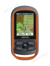
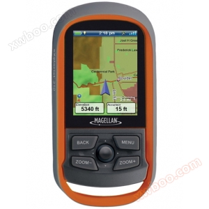
Magellan Explorer 310GPS
Explorer 310 integrates and innovates multiple functions such as navigation, data collection, storage, and retrieval based on full consideration of fi
Product details
Explorer 310 integrates and innovates multiple functions such as navigation, data collection, storage, and retrieval based on full consideration of fieldwork. It combines multiple hardware and software functions, taking into account both appearance and functional design, fully meeting the different needs of your fieldwork.
To adapt to the harsh working environment in the wilderness, Explorer 310 adopts a sturdy and durable, IPX7 waterproof design. The most eye-catching feature is its dynamic semi transparent color screen, providing you with the best visual readability for working in sunlight.
At the same time, its SiRFstarIII GPS chipset can provide you with a 3-meter positioning accuracy. Two AA belts with power supply can work continuously for up to 18 hours without interruption. The hanging ring design can be worn around the neck or tied to a bag, making your field work easy, convenient, and enjoyable.
It can be widely applied in fields such as outdoor exploration, resource investigation, boundary demarcation, and disaster prevention.
Core outdoor navigation
Explorer 310 features a sturdy, durable, and highly waterproof professional design, combining precise navigation with highly sensitive GPS and uneducated maps to create waypoints, record trajectories, and navigate point-to-point routes.
Experiential recording
Explorer 310 integrates a microphone and speaker, allowing field workers to record georeferenced audio information while recording waypoints, and access and play the previous audio in the field.
Convenient area calculation function
Explorer 310 can collect boundary points, automatically calculate the total area of the area, and also input unit prices to calculate the total amount, saving you the hassle of both receiver and calculator in the wilderness.
Advanced 3D perspective view
The Explorer 310 handheld device is equipped with the most accurate full version map of China. The Chinese version of the map allows you to browse visually in two or three dimensions, while also including details of roads and land use. The built-in city navigation software of the handheld device has added a "turn by turn" directional navigation function, allowing you to easily and intuitively navigate your itinerary.
Perfect screen key combination design
Explorer 310 features a user-friendly interface design and four large buttons on the device for easy operation by people of different body types. It also uses joystick style navigation keys for easy switching and data selection between different interfaces, truly achieving one click switching function.
Paperless treasure hunting
Explorer 310 can directly browse, search, and filter downloaded treasure hunting routes on the handheld device, and can directly view up to 20 different feature information for each treasure hunting route, including treasure name, treasure location, treasure point description, treasure owner, treasure size, treasure hunting difficulty, treasure point terrain, treasure hunting hints, and other newly created treasure hunting logs.
Pre installed Chinese version map
Explorer 310 pre installed maps of China, including Chinese Mainland, Hong Kong, Macao and Taiwan. The content covers the complete road network and information on lakes, rivers, and oceans in these regions. Colleagues can also view the land attributes of both urban and rural areas.
Unique humanized hanging ring design
The Explorer 310 features Magellan's iconic hanging ring design, which can be easily hung around the neck or tied to a bag. When picking up the equipment, the rope is located below for easy operation, so you no longer have to worry about rope interference and machinery when working in the wilderness.
Comparison Table of Parameters for the Latest Explorer Series Models:
|
Product Number
|
eXplorist310
|
eXplorist510
|
eXplorist610
|
|
physical indicators
|
|||
|
size
|
56mm x 111mm x 36mm
|
65.3mm x 128mm x 36.8mm
|
65.3mm x 128mm x 36.8mm
|
|
weight
|
147g
|
195g
|
195g
|
|
display resolution, WxH
|
QVGA, 240 x320
|
WQVGA, 240 x 400
|
WQVGA, 240 x 400
|
|
Screen size
|
2.2"
|
3.0"
|
3.0"
|
|
display type
|
Color, semi reflective and semi transparent display screen
|
Color, semi reflective and semi transparent touch screen
|
Color, semi reflective and semi transparent touch screen
|
|
processor
|
400 MHz
|
400 MHz
|
400 MHz
|
|
waterproof rating
|
IPX7
|
IPX7
|
IPX7
|
|
Operating Temperature
|
-10°C ~ +60°C
|
-10°C ~ +60°C
|
-10°C ~ +60°C
|
|
Battery Type
|
2 AA alkaline batteries
|
2 AA alkaline batteries
|
2 AA alkaline batteries
|
|
Battery usage time
|
18 hours
|
15 hours
|
15 hours
|
|
communication interface
|
USB interface, supports NMEA format output
|
USB interface, supports NMEA format output
|
USB interface, supports NMEA format output
|
|
digital camera
|
none
|
have
|
have
|
|
microphone
|
none
|
have
|
have
|
|
speaker
|
none
|
have
|
have
|
|
Storage metrics
|
|||
|
waypoint
|
1000 pieces
|
2000 pieces
|
2000 pieces
|
|
Treasure Point
|
1000 pieces
|
10000 pieces
|
10000 pieces
|
|
route
|
50 pieces, 50 pieces/piece
|
200 pieces, 500 pieces/piece
|
200 pieces, 500 pieces/piece
|
|
flight path
|
50 pieces, 10000 pieces/piece
|
200 pieces, 10000 pieces/piece
|
200 pieces, 10000 pieces/piece
|
|
Available for user storage
|
500 MB
|
500 MB
|
500 MB
|
|
memory
|
2 GB
|
2 GB
|
4 GB
|
|
Expand memory
|
none
|
Micro SD
|
Micro SD
|
|
GPS&Sensor indicators
|
|||
|
GPSchip
|
20 channels, SiRF starIII ™
|
20 channels, SiRF starIII ™
|
20 channels, SiRF starIII ™
|
|
Antenna type
|
Omnidirectional patch antenna
|
Omnidirectional patch antenna
|
Omnidirectional patch antenna
|
|
GPS定位精度
|
3-5 meters
|
3-5 meters
|
3-5 meters
|
|
WAAS/EGNOS/MSAS
|
support
|
support
|
support
|
|
3Axis electronic compass
|
none
|
none
|
have
|
|
Barometric altimetry
|
none
|
none
|
have
|
|
map&navigation
|
|||
|
Pre installed map
|
China Basic Map
|
China Basic Map
|
China Basic Map
|
|
Upload map
|
support
|
support
|
support
|
|
Point of Interest
|
have
|
have
|
have
|
|
coordinate system&datum plane
|
have
|
have
|
have
|
|
User grid
|
have
|
have
|
have
|
|
OneTouchTMmenu
|
have
|
have
|
have
|
|
Practical function
|
|||
|
Hanging mode
|
have
|
have
|
have
|
|
Can be importedGPXdocument
|
have
|
have
|
have
|
|
Paperless treasure hunting
|
have
|
have
|
have
|
|
Image shows
|
have
|
have
|
have
|
|
Sound approaching alarm
|
have
|
have
|
have
|
|
Silent approach alarm
|
none
|
have
|
have
|
|
Vertical section
|
have
|
have
|
have
|
|
Area calculation
|
have
|
have
|
have
|
|
hunting&Fishing Calendar
|
have
|
have
|
have
|
|
sun&Moon information
|
have
|
have
|
have
|
|
in-vehicle/Pedestrian navigation
|
none
|
have
|
have
|
Online inquiry
-
Contacts
-
Company
-
Telephone
-
Email
-
WeChat
-
Verification Code
-
Message Content
-